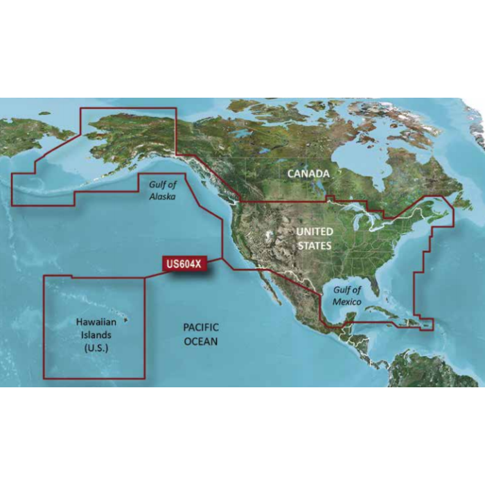
US604x All USA and Coastal Canada , Bahamas to BVI
SKU
US604X-MSD-G3
$249.92
Now featuring data from Explorer Charts for the Bahamas
Provides detailed coverage of the eastern coast of the U.S. from Key West, FL to the Canadian border and the western coast from the Mexican border to Puget Sound, Alaska, Hawaii and major inland rivers, the U.S. Gulf Coast to the Mexican border and the Mexican Gulf Coast thru to the Yucatan. Canadian coverage includes the entire St. Lawrence Seaway, Nova Scotia and New Brunswick. The Great Lakes are covered in their entirety as are the Lake of the Woods. Coverage includes Prince Edward Island, Anticosti Island, Vancouver Island including the Inside and Outside Passages, Aleutian and Channel Islands, Bahamas, Turks and Caicos Islands, Cozumel, Cuba, Hispaniola, Puerto Rico and the U.S. Virgin Islands.
010-C1018-20
Experience unparalleled coverage and brilliant detail when you’re
on the water. BlueChart g3 coastal charts provide industryleading coverage, clarity and detail with integrated Garmin and Navionics content. The charts also calculate suggested routes with Auto Guidance.
The New Garmin Bluechart G3 Features
Advanced Chart Detail and 1ft Contours
Auto Guidance
High Resolution Satellite Imagery
High Resolution Depth Shading
Free Raster Cartography Provided by NOAA


Featured Products

Explorer Chartbook Near Bahamas 11th Ed.
Special Price
$89.95
Regular Price
$99.92

Italian Waters Pilot Revised 11th Edition
Special Price
$89.95
Regular Price
$94.93

Waterway Guide Northern 2024
Special Price
$52.99
Regular Price
$54.92